Timemark helps rePLANET streamline field data collection, improve auditability, and support large-scale ecosystem restoration across multiple regions.
rePLANET is a purpose-driven company committed to large-scale ecological restoration and protection worldwide, funded through the private sector. Their primary objective is to fund the restoration and conservation of landscapes through the generation of carbon and biodiversity credits, whilst ensuring that at least 60% of the revenues each project generates are returned to local stakeholders. rePLANET’s wide portfolio of services includes native tropical forest restoration, mangrove restoration, nature-based advisory services, and marine ecosystem protection and restoration.
A key part of rePLANET’s MRV, QA/QC and project auditing workflows, require capturing georeferenced photographic evidence on the ground. Being able to provide a verifiable digital trail for auditability, reduces risks of data loss or manipulation, and streamlines documentation processes, which is critical for efficient project management in complex carbon and biodiversity funded projects with strict compliance requirements.
As such, capturing georeferenced photographic evidence for actions such as stakeholder consultation meetings, field visits, exchanges of documents and equipment, planting and maintenance events in reforested areas, as well as fieldwork activities for baselining events, are essential processes to be incorporated into most workflows to demonstrate that, amongst other things, ESG and Project Certification requirements are being met. As rePLANET’s portfolio of projects and footprint on the ground scaled, so did the challenge of keeping georeferenced photographic evidence records consistent, verifiable, and organized.
With photos being produced to demonstrate progress and evidence across the board from project staff, local partners and field technicians doing fieldwork, to planting teams during reforestation activities, across multiple projects, the management process to handle all of this information can quickly become labor intensive and a significant time burden to manage. Timemark has significantly assisted in this management, and has been key at scale.
Verified photos. Organized workflow.
The need for systematic workflows for capturing, handling and archiving of georeferenced photographic evidence let rePLANET look at multiple solutions, ultimately crossing paths with the Timemark team. After initial trials and piloting of the system, the rePLANET team adopted the same standardized approach, based on the Timemark system, for capturing and validating georeferenced photographic evidence across all workflows where this will be required.
Through the Timemark system, rePLANET was able to design a standardized, yet adaptable, process that promotes consistency, accuracy, and accountability through having a framework that is auditable and provides an evidence trail across different workflows, ensuring that best practices are followed (as per the project’s alignment with best practices in general and also with ESG compliance, VCS and CCB, and standard requirements).
Stronger evidence and Smoother Communication
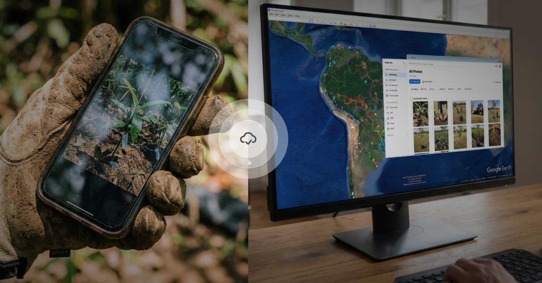
To improve map-based communication between project staff, field technicians and landowners in cases where satellite imagery and remote sensing data can misclassify silvopastoral systems as forest, Timemark collaborated with rePLANET to enhance their KMZ export feature for the ground. With just a few clicks, one can now download project photos as a KMZ file and view them overlaid on common satellite imagery tools like Google earth. Ground-truthing is a key part of project diligence, and so this feature is very useful for communicating real field conditions to stakeholders, especially when satellite data alone falls short.
From the field into the system
Photos captured across projects and regions all feed into a project specific Teamspace. This removes the need for manual uploads, as photos, once captured, automatically are uploaded to where they need to be, organized by project and easy to access.
Custom Access and Role Control
rePLANET helped shape Timemark’s role-based permissions. Admins can control who sees what and what the functionality they have in the system. From full editors to view-only users, this keeps data secure and teams focused on areas .
Verifiable georeferenced photographic evidence
Each image captured in the app includes a unique code that enables auditable accessible traceability to validate the veracity of each photo, validate GPS coordinates and provide a photo timestamp. If there is ever a need or request for further information about a captured photo, this system facilitates this traceable information to be provided.
"Timemark has become an important part of our MRV and QA/QC workflows helping us capture verifiable, georeferenced photographic evidence at scale across our project activities. It streamlines field data collection, strengthens auditability, and ensures that our growing portfolio remains transparent, consistent, and compliant”
Favorite Features: Location stamping, centralized photo management, KMZ export, and Timemark photo verification
Timemark makes jobsite photo documentation simple. Capture verified photos, work reliably offline, and keep everything organized in one place. Built for field teams with straightforward, scalable pricing.
Downloads
10M+
Photos Taken
5.1B
Hours saved weekly
6
Rated
4.8/5